SPC - Hurricane Idalia Related Mesoscale Discussions
Posted by cypresstx on 8/29/2023, 3:02 pm
https://www.spc.noaa.gov/products/md/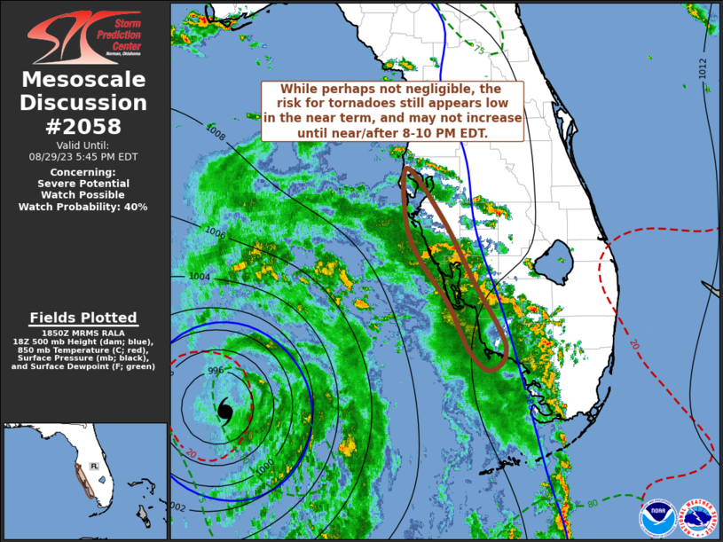 Mesoscale Discussion 2058 NWS Storm Prediction Center Norman OK 0152 PM CDT Tue Aug 29 2023 Areas affected...southwestern through west central Florida coastal areas Concerning...Severe potential...Watch possible Valid 291852Z - 292145Z Probability of Watch Issuance...40 percent SUMMARY...Potential for an isolated, brief tornado may not be completely negligible in the near term, but still appears generally low, and may not increase appreciably until at least this evening closer to the Fort Myers into Tampa Bay vicinity. DISCUSSION...After migrating north-northwestward for at least a period late this morning, the motion of Idalia has trended a bit more to the north across the southeastern Gulf of Mexico. This is 200+ miles offshore of southwestern through west central Florida coastal areas, which have been increasingly impacted by the far outer eastern convective bands. The arrival of the lead convective band, and some preceding discrete cells, appears to have coincided with some strengthening of south-southeasterly flow to 30-40+ in the 850-700 mb layer. However, based on NAM and Rapid Refresh forecast soundings, and VWP data, speed shear dominates the low-level hodograph, with weak turning with height limited to a shallow near-surface layer. These type of hodographs may not change appreciably until near/after 00-02Z this evening, near the Fort Myers into Tampa Bay vicinity, where/when forecast soundings indicate a period of some increase in turning with height and increasing speed in the lower to mid-levels (and enlarging clockwise curved hodographs), with the continued northward progression and closer approach of the circulation center to the coast. ..Kerr/Thompson.. 08/29/2023 ...Please see www.spc.noaa.gov for graphic product... ATTN...WFO...MFL...TBW... LAT...LON 28048273 27468228 26768189 26008147 25728167 25958194 26488220 26968255 27398274 28048273 |
1
In this thread:
SPC - Hurricane Idalia Related Mesoscale Discussions - cypresstx, 8/29/2023, 3:02 pm
Post A Reply