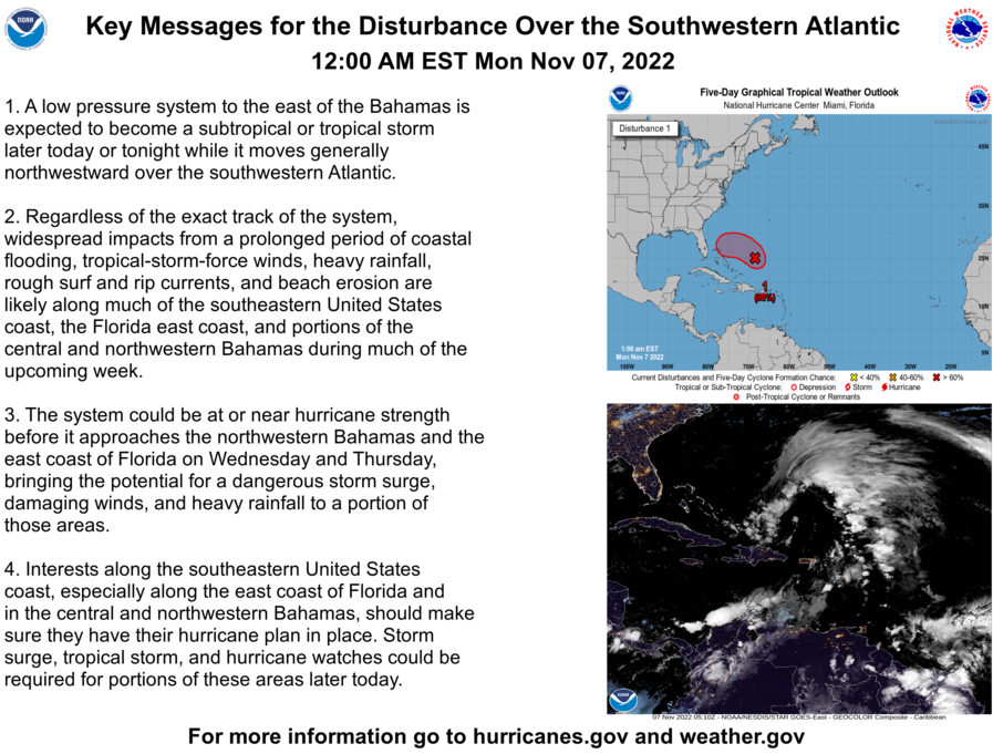
Fri 5/15, 2 PM EDT - Special TWO - 80/80% over 2/5 days
Posted by cypresstx on 5/15/2020, 2:51 pm
36
In this thread:
First Storm Near Carolina Coastline? - Target, 5/10/2020, 9:32 pm
- 11:00 AM AST Tue May 19 - Post-Tropical, Last Advisory - cypresstx, 5/19/2020, 12:21 pm
- Is Arthur going to loop and come back to visit over the holiday week? - AquaRN, 5/18/2020, 12:11 pm
- for 1st storm of Atlantic season - cypresstx, 5/18/2020, 9:42 am
- Re: First Storm Near Carolina Coastline? - AquaRN, 5/17/2020, 12:53 pm
- Re: First Storm Near Carolina Coastline? - Beachlover, 5/17/2020, 4:51 pm
- Re: First Storm Near Carolina Coastline? - Target, 5/17/2020, 6:06 pm
- Chris added Funktop as an option in recon layers - cypresstx, 5/17/2020, 7:38 pm
- Re: Chart Testing - O/T - Chris in Tampa, 5/17/2020, 8:43 pm
- you're amazing Chris - cypresstx, 5/17/2020, 8:59 pm
- Re: you're amazing Chris - Chris in Tampa, 5/18/2020, 7:35 am
- you're amazing Chris - cypresstx, 5/17/2020, 8:59 pm
- Re: Chart Testing - O/T - Chris in Tampa, 5/17/2020, 8:43 pm
- Chris added Funktop as an option in recon layers - cypresstx, 5/17/2020, 7:38 pm
- Re: First Storm Near Carolina Coastline? - Target, 5/17/2020, 6:06 pm
- Re: First Storm Near Carolina Coastline? - Beachlover, 5/17/2020, 4:51 pm
- 5am EDT Sunday: Tropical storm warning issued for North Carolina Outer Banks for Arthur - Chris in Tampa, 5/17/2020, 5:44 am
- Now Tropical Depression One - Chris in Tampa, 5/16/2020, 6:25 pm
- Atlantic - Special TWO - cypresstx, 5/12/2020, 1:58 pm
- Wed 5/13 AM - 0/70% over 2/5 days - cypresstx, 5/13/2020, 9:40 am
- Thur 5/14, 2:40PM EDT - Special TWO - 70/80% over 2/5 days - cypresstx, 5/14/2020, 3:33 pm
- HWRF: 50 kt Super Storm Monday Morning - Target, 5/16/2020, 12:15 am
- HWRF: Hurricane Arthur Tuesday Morning - Target, 5/16/2020, 9:16 am
- Offshore Waters Forecast (Mid Atlantic) - cypresstx, 5/16/2020, 9:47 am
- recon mission 1 into 90L - cypresstx, 5/16/2020, 11:14 am
- Satellite - GeoColor - tvsteve, 5/16/2020, 12:31 pm
- HMON: Hurricane Arthur by NC Monday Morning - Target, 5/17/2020, 2:40 am
- Re: HMON: Hurricane Arthur by NC Monday Morning - jimw, 5/17/2020, 9:34 am
- Re: HMON: Hurricane Arthur by NC Monday Morning - Beachlover, 5/17/2020, 4:49 pm
- Re: HMON: Hurricane Arthur by NC Monday Morning - Beachlover, 5/18/2020, 1:35 am
- Re: HMON: Hurricane Arthur by NC Monday Morning - jimw, 5/18/2020, 4:58 pm
- Re: HMON: Hurricane Arthur by NC Monday Morning - Beachlover, 5/19/2020, 12:59 am
- Re: HMON: Hurricane Arthur by NC Monday Morning - hurricane, 5/18/2020, 10:59 pm
- HMON: Hurricane Arthur Tuesday - Target, 5/18/2020, 11:22 pm
- Arthur was just on the edge of becoming a hurricane - Target, 5/25/2020, 1:31 am
- HMON: Hurricane Arthur Tuesday - Target, 5/18/2020, 11:22 pm
- Re: HMON: Hurricane Arthur by NC Monday Morning - jimw, 5/18/2020, 4:58 pm
- Re: HMON: Hurricane Arthur by NC Monday Morning - Beachlover, 5/18/2020, 1:35 am
- Check out the satellite loops... - Target, 5/17/2020, 10:27 am
- and Rutger's SSTs - Target, 5/17/2020, 11:54 am
- TCHP - cypresstx, 5/17/2020, 12:08 pm
- Depth 26.C Isotherm - cypresstx, 5/17/2020, 12:14 pm
- Last Week's Depth 26.C Isotherm - Target, 5/17/2020, 2:35 pm
- Depth 26.C Isotherm - cypresstx, 5/17/2020, 12:14 pm
- TCHP - cypresstx, 5/17/2020, 12:08 pm
- and Rutger's SSTs - Target, 5/17/2020, 11:54 am
- Re: HMON: Hurricane Arthur by NC Monday Morning - Beachlover, 5/17/2020, 4:49 pm
- Re: HMON: Hurricane Arthur by NC Monday Morning - jimw, 5/17/2020, 9:34 am
- HMON: Hurricane Arthur by NC Monday Morning - Target, 5/17/2020, 2:40 am
- Satellite - GeoColor - tvsteve, 5/16/2020, 12:31 pm
- recon mission 1 into 90L - cypresstx, 5/16/2020, 11:14 am
- Offshore Waters Forecast (Mid Atlantic) - cypresstx, 5/16/2020, 9:47 am
- HWRF: Hurricane Arthur Tuesday Morning - Target, 5/16/2020, 9:16 am
- HWRF: 50 kt Super Storm Monday Morning - Target, 5/16/2020, 12:15 am
- Thur 5/14, 2:40PM EDT - Special TWO - 70/80% over 2/5 days - cypresstx, 5/14/2020, 3:33 pm
- Wed 5/13 AM - 0/70% over 2/5 days - cypresstx, 5/13/2020, 9:40 am
Post A Reply
This thread has been archived and can no longer receive replies.