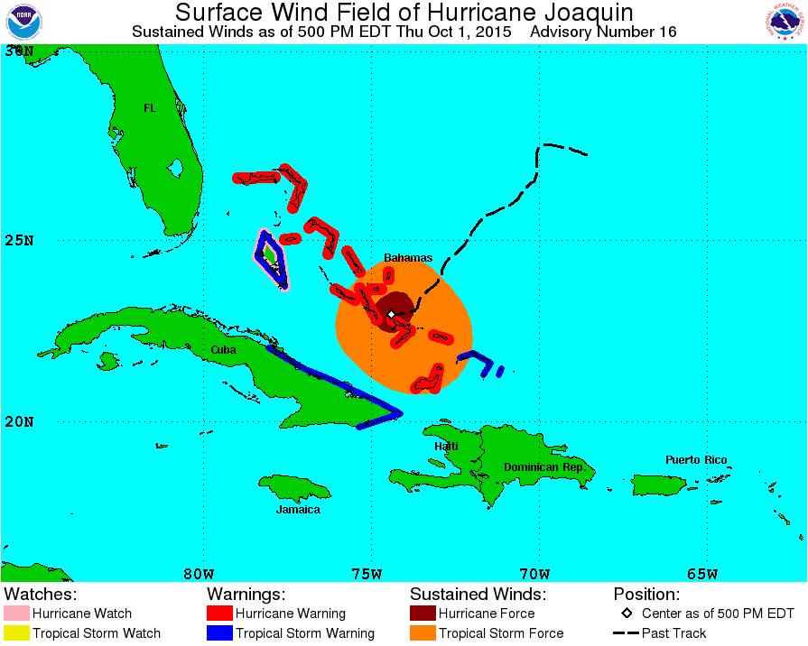
5pm thur, oct 1, 936mb, 130mph, sw at 6mph
Posted by
cypresstx on 10/1/2015, 5:34 pm
http://www.nhc.noaa.gov/#JOAQUIN or http://www.nhc.noaa.gov/mobile/ for you cell phone ppl
000
WTNT41 KNHC 012054
TCDAT1
HURRICANE JOAQUIN DISCUSSION NUMBER 16
NWS NATIONAL HURRICANE CENTER MIAMI FL AL112015
500 PM EDT THU OCT 01 2015
The earlier Air Force Reserve Hurricane Hunter aircraft reported 700-mb flight-level winds of 120 kt in the southwestern eyewall, with a subsequent 114-kt surface wind estimate from the Stepped Frequency Microwave Radiometer in the southeastern eyewall. The last central pressure extrapolated from the aircraft data was 936 mb. In addition, satellite intensity estimates from TAFB, SAB, and CIMSS are now in the 115-127 kt range. Based on these data, the intensity was increased to 115 kt at 1800 UTC, making Joaquin a Category 4 hurricane. While this advisory will not increase the intensity any further, it is expected that the next aircraft arriving in the hurricane near 0000 UTC will find a stronger system.
Joaquin is expected to intensify a little more during the next 12 hours or so as it remains over very warm waters and in an environment of decreasing vertical shear. After that time, there could be some fluctuations in intensity due to eyewall replacement cycles. While there remains some uncertainty regarding the intensity in the 48-96 hour range, the new forecast is similar to the previous forecast in calling for a steady weakening during this period. Overall, the intensity forecast lies near the upper edge of the guidance envelope.
Joaquin has moved with a more westward component during the past few hours and the initial motion is now 235/5. Water vapor imagery shows a mid- to upper-level ridge north of the hurricane, with a developing deep-layer trough over the eastern and southeastern United States. The dynamical models forecast this trough to become a cut-off low as it moves southeastward and weakens the ridge. This pattern evolution should cause Joaquin to turn northward in 12-24 hours. The guidance after 48 hours has changed somewhat since the last advisory, with the GFS and the UKMET moving farther to the east and lying closer to the ECMWF. In addition, the HWRF has made a big jump to the east and now shows an offshore track. These changes have pushed the consensus models farther eastward.
The Canadian, GFDL, and NAVGEM models are holdouts, however - still calling for Joaquin to interact with the United States trough and turn northwestward toward the U. S. coast. The new forecast track is adjusted to the east of the previous forecast between 48-120 hours, but it still lies well to the left of the GFS, UKMET, ECMWF, HWRF, and the consensus models. Further eastward adjustments to the track are likely.
KEY MESSAGES:
1. Joaquin's slow motion means that extremely dangerous conditions will continue over portions of the warning areas in the Bahamas well into Friday.
2. A strong majority of the forecast models are now in agreement on a track farther away from the United States east coast. We are becoming optimistic that the Carolinas and the mid-Atlantic states will avoid the direct effects from Joaquin. However, we cannot yet completely rule out direct impacts along on the east coast, and residents there should continue to follow the progress of Joaquin over the next couple of days.
3. Efforts to provide the forecast models with as much data as possible continue, with twice daily NOAA G-IV jet missions in the storm environment, and extra NWS balloon launches.
4. Even if Joaquin moves out to sea, strong onshore winds associated with a frontal system will create minor to moderate coastal flooding along the coasts of the mid-Atlantic and northeastern states through the weekend. In addition, very heavy rains, not associated with Joaquin, are expected to produce flooding over portions of the Atlantic coastal states. Please see products issued by local NWS Forecast Offices.
FORECAST POSITIONS AND MAX WINDS
INIT 01/2100Z 23.0N 74.4W 115 KT 130 MPH
12H 02/0600Z 23.2N 74.7W 120 KT 140 MPH
24H 02/1800Z 24.4N 74.7W 120 KT 140 MPH
36H 03/0600Z 25.9N 74.1W 120 KT 140 MPH
48H 03/1800Z 28.4N 73.3W 110 KT 125 MPH
72H 04/1800Z 33.0N 72.5W 90 KT 105 MPH
96H 05/1800Z 37.0N 72.0W 70 KT 80 MPH
120H 06/1800Z 41.0N 69.0W 55 KT 65 MPH
$$
Forecaster Beven
http://www.hurricanecity.com/models/data.cgi?basin=al&year=2015&storm=11
loop: http://www.nhc.noaa.gov/archive/2015/graphics/al11/loop_R.shtml
 |
293
In this thread:
5pm thur, oct 1, 936mb, 130mph, sw at 6mph - cypresstx, 10/1/2015, 5:34 pm- Recon Images - Chris in Tampa, 10/1/2015, 8:49 pm
- 932mb, 12 knots of wind - Chris in Tampa, 10/1/2015, 7:45 pm
- Re: 5pm thur, oct 1, 936mb, 130mph, sw at 6mph - SC, 10/1/2015, 6:02 pm
Post A Reply
This thread has been archived and can no longer receive replies.
